Routen
Lede, Belgium
Four Extremes hiking trail loop 2
9.8 km 2.6/5
Walk along the "Four Extremes" of Scheldeland: the parishes of Impe, Wanzele, Smetlede-Oordegem and Serskamp. Go through... read more
© Stadia Maps © OpenStreetMap contributors, © NodeMapp
Put on your hiking shoes and discover the most beautiful hiking routes in Smetlede (Lede)! You will also see all places where hiking nodes are currently available.
Below you will find the latest hiking trails in Smetlede (Lede) offered by official tourism organisations or by verified users of our platform.
Pathfinders are hikers who share their hiking adventures in Smetlede (Lede) with you.
Looking for an adventure? Try our 'Surprise Me' feature! Enter your preferences below, and we will suggest a number of hikes using the hiking nodes in Smetlede (Lede). The routes are calculated in real-time using the hiking node network.
9.8 km 2.6/5
Walk along the "Four Extremes" of Scheldeland: the parishes of Impe, Wanzele, Smetlede-Oordegem and Serskamp. Go through... read more
11.4 km 2.5/5
Walk along the 'Four Extremes' of Scheldeland: the parishes of Impe, Wanzele, Smetlede-Oordegem and Serskamp. Go through... read more
5.4 km 4.1/5
This hiking trail takes you along unpaved paths through the Geelstervallei, a green pearl located between Lede and Impe.... read more
23.2 km
This walking route sends you on a sustainable walk, as both your start and end point are at a train station. Ideal for t... read more
9.1 km
On this route between the stations of Wichelen and the borough of Schellebelle, you’ll never lose sight of the Scheldt. ... read more
10.8 km 4.3/5
The Wetterse warande dunes form a remarkable piece of Scheldt nature, which cause the Siint-Gertrudis church to tower hi... read more
13.7 km
If you want to be blown away by your hiking socks, you should follow our Wetterse Floriculture Hiking Trail. It winds th... read more
16.3 km 4.5/5
This hiking trail starts at the Burst station and takes you through open landscapes, bits of forest and cozy picnic area... read more
8.2 km 4.3/5
We start in the castle park of Berlare for a varied trip through Scheldt nature. One moment we are clearly below Scheldt... read more
5.3 km 3.5/5
The valley owes its name to the star-of-Bethlehem. You can find it in only a few places in Flanders. The valley, with a ... read more
13.3 km
Departure: Sint-Baafskerk - Wanzele Village - Wanzele Walk through the Geelstervallei, which is crossed by the Molenbeek... read more
28.4 km
I've been living in this neighborhood for 35 years, yet I'm still pleasantly surprised each time by the many beautiful, ... read more
14.2 km 4/5
Departure: parking at cultural center Emotia - Oudenaardsesteenweg 456 - 9420 Erpe-Mere This walk is approximately 2/3 i... read more
9.8 km
Departure: Dorpsplein, Massemen A walk that takes us through lots of natural beauty. The area is known for its many orna... read more
8.6 km 4.2/5
Beautiful paths despite the rain, perfect for walking with the dog who loves to play in the mud. The mud is present alon... read more
8.6 km 4.8/5
Beautiful nature walk via narrow and unpaved paths to Solegembos and Honegem Nature Reserve, with beautiful views and a ... read more
15.7 km 4.5/5
🍃Kalkense Meersen🍃 Self-made route with junction points. A mix of paved and unpaved paths. And especially enjoy: 🍃The... read more
16 km
Departure: parking OLV van Zeven Weeën and Sint-Jozefkerk - Schoonaardebaan 56 - Schoonaarde or NMBS Station Schoonaarde... read more
13 km
Park for free on Kasteeldreef in Laarne. Your walk begins and ends at one of the best-preserved moated castles in Belgiu... read more
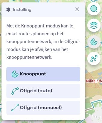
The Route Planner Pro has changed a bit on our new website. The ability to plan routes that deviate from the hiking network is now integrated into our node planner (continue reading below image):
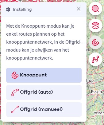
If you open our route planner, you can press the magnet symbol in the upper right corner. If you then choose Offgrid (auto) (automatic route planning) or Offgrid (manual) (connecting places manually), you can select places on the map and plan a route that deviates (partially or completely) from the hiking network.
You can switch between Node and Offgrid mode to create a route that runs partly along nodes and partly away from the node network.
The Route Planner Pro has changed a bit on our new website. The ability to plan routes that deviate from the bicycle network is now integrated into our node planner (read more below image):

If you surf to our route planner, you can press the magnet symbol in the upper right corner. If you then choose Offgrid (auto) (automatic route planning) or Offgrid (manual) (connecting places manually), you can select places on the map and plan a route that deviates (partially or completely) from the biking network.
You can switch between Node and Offgrid mode to create a route that runs partly along nodes and partly away from the node network.
Are you sure you want to log out?
With this QR-code or text code you can login to our app. Open the login screen of the NodeMapp Hike app or NodeMapp Bike app and press the button with the QR-code. In the same screen, you can also enter the text code (case sensitive!) if you prefer.
Time remaining to log in with this code:
01:00