 Hiking
 Login
Login
 More
More
 EN
EN
 Premium
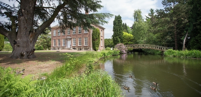
Berlare castle park hiking trail
automatic translation
11.4 km • Berlare
 official route
7.00516 13 4.3/5
 Addresse starting point (approximate)
Frankrijkstraat 1, 9290 Berlare
 signage
The route is fully signposted with nodes.
 Description
We start in the castle park of Berlare for a varied trip through Scheldt nature. One moment we are clearly below Scheldt level. A moment later, we are getting ready for a tough climb through the dunes that the river created centuries ago in the curve of Berlare.
TheCastle Park of Berlare hiking trailis offered to you byRouten, an initiative of Tourism East Flanders.
automatic translation
 nodes to follow
0 km
0.4 km
1.7 km
2.3 km
2.9 km
3.9 km
4 km
4 km
4.3 km
5.3 km
6.2 km
6.8 km
7.1 km
7.3 km
7.4 km
7.7 km
8.3 km
8.5 km
9.1 km
9.9 km
9.9 km
9.9 km
10.9 km
11.3 km
Sunday, May 10, 2026 by P.D.Beautiful, peaceful, 95% nature. I'll do this one too.
automatic translation
Tuesday, November 11, 2025 by S.V.Very beautiful route through beautiful nature. Thoroughly enjoyed the tranquility and nature.
automatic translation
Tuesday, April 30, 2024 by J.G.Very nice route, lots of green, lots of variety, surprising bits of nature and everything beautifully maintained
automatic translation
Sunday, February 5, 2023 by C.D.Very nice varied and peaceful hike. Enjoyed it. Definitely worth repeating. Much through nature, along the Scheldt....
automatic translation
Sunday, May 23, 2021 by Belle La DolceBeautiful and very varied walk, along many beautiful nature spots and start at point 23 in the castle park, occasionally paved roads but in the green which makes up for a lot... along the park, a piece of forest, fields and meadows, along the flooded horse pasture where many water birds can be seen, the forest was dotted with mayflies, highly recommended!
automatic translation
Saturday, April 24, 2021 by G.D.Beautiful walk , start in the park of the castle, along beautiful nature, the Scheldedijk, there it was busier because of cyclists . We will definitely do them again.
automatic translation
Sunday, April 11, 2021 by luc maesStarting at the castle of Berlare and via the nature reserve Paardeweide and over the old dunes of the Scheldt : a lot of paving, recommended and not too long. At point Scheldt possibility of refreshment and drink after Corona times then....
automatic translation
Wednesday, November 25, 2020 by R.D.nice walk seen as a whole , starting point is not right ! does start in castle park , still quite a lot of asphalt but nice pieces though , no high flyer , but certainly not bad either !my fellow hikers were less enthusiastic !
automatic translation
Tuesday, November 24, 2020 by L.D.nice walk - start in castle park via quiet field paths - part on dike along the Scheldt - via several pools - along fields - through bushes ... pleasant walk
automatic translation
Sunday, October 18, 2020 by F.V.Beautiful trail with lots of diversity, gets 4.5 stars from us, just under five, half a point we have withheld because only on the last km was a bench to be found, 10.5 km is already a long way, but we are not going to whine about it, hats off to the people who have made this route!
automatic translation
Sunday, October 4, 2020 by S.T.Very nice and varied hike. Don't let the comment around the regional road scare you. Is safe and takes as little as 2 minutes.
automatic translation
Sunday, May 24, 2020 by Peter de RyckeNice walk. only the part along the Scheldt is a bit less because of the busy bicycle traffic.
automatic translation
Sunday, May 3, 2020 by Freddy Van de VeldeVery nice walk - variety - and catering at start and finish , and halfway brasserie brughuis on the Scheldedijk.
Too bad there's a small stretch of regional road to get there.
automatic translation


 Upgrade to Premium Plus
