Toerisme Provincie Antwerpen
Geel, Belgium
Safari
4.9 km
"A new child-friendly nature-educational hike in the Belgian forests! Lieven Scheire is your personal safari guide and t... read more
© Stadia Maps © OpenStreetMap contributors, © NodeMapp
Put on your hiking shoes and discover the most beautiful hiking routes in Millegem (Mol)! You will also see all places where hiking nodes are currently available.
Below you will find the latest hiking trails in Millegem (Mol) offered by official tourism organisations or by verified users of our platform.
Pathfinders are hikers who share their hiking adventures in Millegem (Mol) with you.
Looking for an adventure? Try our 'Surprise Me' feature! Enter your preferences below, and we will suggest a number of hikes using the hiking nodes in Millegem (Mol). The routes are calculated in real-time using the hiking node network.
9.3 km 4/5
Dunes in the Kempen? Sure. After the last ice age, the expanding sand of the Grote Nete created sandy hills. Today in Ge... read more
9.2 km 4.2/5
Land dunes are sandy hills formed after the last ice age, by the blowing out of sand from the rivers. This specific land... read more
8.6 km 4.2/5
This beautiful hike starts at youth house De Faar in Meerhout. Along quiet forest roads you will explore this peaceful, ... read more
7.4 km 5/5
This hike forms the typical backdrop of a Kempen scene. You pass woods, meadows, marshes, fens, dunes as well as heathla... read more
4.5 km
"In the Griesbroek you walk in the varied landscape of the Grote Nete Valley, between Hulsen and Olmen. Besides the Grot... read more
12 km
In the southeast of Geel, the Grote Nete meanders lazily through the fields of the Malesbroek nature reserve. It encompa... read more
7 km
Beautiful nature walk that mainly takes place through the forest. Millegem is one of the twelve hamlets of the Belgian m... read more
8.9 km 5/5
We took this hike on 15/02/2026 (12,898 steps). This wooded route partially goes through the 'Oude Bleken' area. The nam... read more
8 km
Achterbos, a picturesque hamlet in the Belgian municipality of Mol, offers a beautiful and diverse hiking experience. In... read more
10.7 km 4/5
This route is partly "not" signposted! You can park along the N103 in Ezaart. The walk begins with a short stretch along... read more
6.8 km 4/5
Beautiful junction walk in the Belgian forests. Paved roads, avenues, and narrow paths alternate. Ideal for those who lo... read more
4.2 km
Beautiful varied, rural walk in Mol Millegem. One starts at a street called Stokt, at KP 91. Millegem is one of the twel... read more
6.9 km 5/5
For this beautiful walk through network points, we parked the car on the semi-paved 'Volmolenweg', near the 'Kempense Mo... read more
8.3 km
Beautiful junction walk that starts at B&B Het Verloren Schaep in Meerhout. We cross the N110 to return to that same N11... read more
11.4 km 5/5
Beautiful, varied nature junction walk that starts at Castelsebaan in Mol. It passes by lock 7 in Geel. The canal is cro... read more
6.6 km 3.5/5
We have called this beautiful varied walk 'Mol Zuiderring - Molse Nete' because it takes the hiker quite a distance alon... read more
15.9 km 4/5
Beautiful varied loop walk that starts at the 'Mol' station. During this walk, which alternates between paved and unpave... read more
8.5 km
Hiked on 5/27/2026 Parking: Parking Bowling Den Bruul, Bel (Geel) Distance hiked according to GPS: 8.4 km Signposting: G... read more
11.4 km
We did this walk on 14/03/2025 (14,236 steps). We felt like taking a walk along a canal and decided to make a circular r... read more
7.9 km 4/5
Heidehuizen offers a wonderful and varied hiking experience. It is one of the twelve hamlets of Mol, located in a wooded... read more
The Route Planner Pro has changed a bit on our new website. The ability to plan routes that deviate from the hiking network is now integrated into our node planner (continue reading below image):
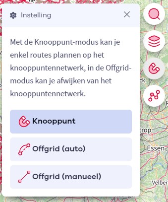
If you open our route planner, you can press the magnet symbol in the upper right corner. If you then choose Offgrid (auto) (automatic route planning) or Offgrid (manual) (connecting places manually), you can select places on the map and plan a route that deviates (partially or completely) from the hiking network.
You can switch between Node and Offgrid mode to create a route that runs partly along nodes and partly away from the node network.
The Route Planner Pro has changed a bit on our new website. The ability to plan routes that deviate from the bicycle network is now integrated into our node planner (read more below image):

If you surf to our route planner, you can press the magnet symbol in the upper right corner. If you then choose Offgrid (auto) (automatic route planning) or Offgrid (manual) (connecting places manually), you can select places on the map and plan a route that deviates (partially or completely) from the biking network.
You can switch between Node and Offgrid mode to create a route that runs partly along nodes and partly away from the node network.
Are you sure you want to log out?
With this QR-code or text code you can login to our app. Open the login screen of the NodeMapp Hike app or NodeMapp Bike app and press the button with the QR-code. In the same screen, you can also enter the text code (case sensitive!) if you prefer.
Time remaining to log in with this code:
01:00