Toerisme Provincie Antwerpen
2440 Geel, Belgium
Something to eat and drink
12 km
In the southeast of Geel, the Grote Nete meanders lazily through the fields of the Malesbroek nature reserve. It encompa... read more
© Stadia Maps © OpenStreetMap contributors, © NodeMapp
Put on your hiking shoes and discover the most beautiful hiking routes in Stelen (Geel)! You will also see all places where hiking nodes are currently available.
Below you will find the latest hiking trails in Stelen (Geel) offered by official tourism organisations or by verified users of our platform.
Pathfinders are hikers who share their hiking adventures in Stelen (Geel) with you.
Looking for an adventure? Try our 'Surprise Me' feature! Enter your preferences below, and we will suggest a number of hikes using the hiking nodes in Stelen (Geel). The routes are calculated in real-time using the hiking node network.
12 km
In the southeast of Geel, the Grote Nete meanders lazily through the fields of the Malesbroek nature reserve. It encompa... read more
9.2 km
Looking at the map of Eindhout, one sees a patchwork of houses, businesses, playgrounds, forests, open nature, water cat... read more
6.8 km 4.8/5
Eye-catchers on this hike? Two imposing castles and the Grote Nete. You follow the meandering river in the nature reserv... read more
19.9 km
This varied walk starts at Tourism Westerlo and takes you past beautiful natural scenery and heritage sites that spark t... read more
9.1 km
Take a walk between Westerlo and Tongerlo in the shade of imposing tree-lined avenues, a legacy of the Norbertines and o... read more
8.4 km
An 8.5-km walk along quiet roads. Tongerlo Abbey (KP 1) is the starting point of your walk. Before you set off, take a m... read more
7.6 km
The impressive Abbey of Tongerlo, imposing avenues, fairy-tale castles ... Westerlo has it all. And that is largely due ... read more
7.1 km
"For centuries we have been whispering stories to each other. About (super)faith, wandering lights, witches and rituals.... read more
8.6 km 4.2/5
This beautiful hike starts at youth house De Faar in Meerhout. Along quiet forest roads you will explore this peaceful, ... read more
7.4 km 5/5
This hike forms the typical backdrop of a Kempen scene. You pass woods, meadows, marshes, fens, dunes as well as heathla... read more
13.1 km
Delightful walk from Oosterlo to Zammel, via Varendonk. Through the Trichelbroek nature reserve and along the banks of t... read more
11.7 km 4/5
Beautiful nature walk along the Grote Nete and the Grote Laak. Parking is available in the spacious parking area on the ... read more
10.1 km 1/5
We did this surprisingly beautiful walk a bit out of necessity. Our car had to go into a garage in Geel for maintenance.... read more
9.7 km
This very varied walk we did, just like the Geel-Larum walk, also out of necessity. This time the car needed repairs. We... read more
7.6 km
Walked on 02/13/2026 Parking: Kemeldijk Winkelomheide (Municipal primary school). Walked distance according to GPS: 7.49... read more
10.7 km
Attention: During wet periods, there is a chance of muddy trails and flooding between nodes 159-214-328 and 170. This be... read more
15.4 km 0.5/5
Departure: Saint Lawrence Church - Zammelseweg 195 - Geel The first half of the walk follows the banks of the Grote Nete... read more
9.1 km
Attention in the period 01/04/2024 - 01/04/2026! Routes and junctions may be interrupted during the SIGMA works (KP's 21... read more
15.2 km
Beautiful varied walk from the station of Geel to the station of Herentals. The first four kilometers are paved. Once pa... read more
3.5 km
Parking: Carpool parking Nieuwe Baan, Laakdal. Signage: Junctions/GPS/Hiking app. Short walk through Eindhoutberg and Ho... read more
10.6 km
Beautiful node point walk in Westerlo. Westerlo is not called the pearl of the Kempen for nothing. The walk starts along... read more
8.2 km 5/5
Parking: Luihoeve, Bredestraat 62 Meerhout Signposting: Junction points Alternating forest paths and paved roads, you wa... read more
7.5 km 5/5
On this route, one passes the Alvinnenberg, where according to legend, the alvermannetjes lived and were active. Alverma... read more
14.2 km
Beautiful varied walk, partially along the Kleine Laak. In the valley of the Kleine Laak, you can find the following nat... read more
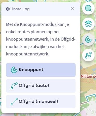
The Route Planner Pro has changed a bit on our new website. The ability to plan routes that deviate from the hiking network is now integrated into our node planner (continue reading below image):
If you open our route planner, you can press the magnet symbol in the upper right corner. If you then choose Offgrid (auto) (automatic route planning) or Offgrid (manual) (connecting places manually), you can select places on the map and plan a route that deviates (partially or completely) from the hiking network.
You can switch between Node and Offgrid mode to create a route that runs partly along nodes and partly away from the node network.
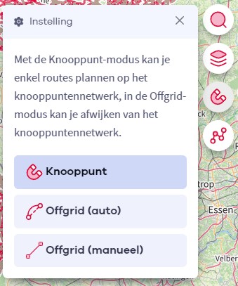
The Route Planner Pro has changed a bit on our new website. The ability to plan routes that deviate from the bicycle network is now integrated into our node planner (read more below image):

If you surf to our route planner, you can press the magnet symbol in the upper right corner. If you then choose Offgrid (auto) (automatic route planning) or Offgrid (manual) (connecting places manually), you can select places on the map and plan a route that deviates (partially or completely) from the biking network.
You can switch between Node and Offgrid mode to create a route that runs partly along nodes and partly away from the node network.
Are you sure you want to log out?
With this QR-code or text code you can login to our app. Open the login screen of the NodeMapp Hike app or NodeMapp Bike app and press the button with the QR-code. In the same screen, you can also enter the text code (case sensitive!) if you prefer.
Time remaining to log in with this code:
01:00