 What do you want to do?
 Login
Login More
More EN
EN Premium
Planning a route
Written by
Yannick Mertens 23/07/2023automatic translation
General
Via our route planner in the app, you can plan routes along nodes. If you are a Premium user, you can also plan routes that deviate from the node network. In this article, we explain in detail how you can plan routes.
How to start planning a route?
When you log into the app, you will notice that our route planner appears directly on the home screen. This allows you to immediately start planning a cycling or walking route to your liking.
You should preferably go to an area where nodes are present. You can do this by moving the map with your finger (swiping). To zoom in or out, pinch two fingers together or apart.
Alternatively, you can choose Search place from the menu at the top right (three dots). Enter the desired municipality or city, and it will appear in the list. Then, tap on it, and the map will be centered on your chosen region.
How to create a route?
Just like on our website, you can choose in the app to plan a route yourself (Point-to-point) or to be surprised by our route planner (Surprise Me). You can select your preference at the bottom left of the map.
The icon below indicates that the Point-to-point mode is active:

If you see the icon below, the Surprise Me mode is active:

To switch modes, simply tap on the icon, and the other mode will be activated.
Point-to-point
Here we explain step-by-step how to plan a route using the Point-to-point method.
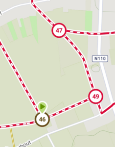
Step 1: Choose a starting (node) point
Navigate on the map to the region where you want to start and find the nearest node to your desired starting place. Tap on it, and this node will be marked with a green marker (see screenshot below). This is your starting point.
Step 2: Select intermediate (node) points and the final (node) point
You have chosen the starting point by tapping on it. Now do the same with the intermediate points and the endpoint. Tap on the (node) points along which you want to cycle or walk. The last marked (node) point will get a red marker. At this moment, that specific (node) point is your endpoint.
Step 3: Select a route option
Once your walk or bike ride is planned, tap the Done button at the bottom of the screen. A menu will appear on your screen with options for what you can do with the route. The different options are:
- Add to favorites
- Share route
- Navigate along route (Premium only)
- Elevation profile (Premium only)
- Offline maps (Premium only)
- Create GPX (Premium only)
Select the desired option from the menu.
Surprise Me
Here we explain step-by-step how to plan a route using the Surprise Me method.
Step 1: Choose a starting (node) point
Navigate on the map to the region where you want to start and find the nearest node to your desired starting place. Tap on it, and a pop-up will appear on your screen. In the gray text field, enter the number of kilometers you want to walk or cycle, then tap the Calculate button.
Our route planner will then calculate a loop starting from the chosen starting node.
Step 2: Select a route option
Once your walk or bike ride is planned, tap the Done button at the bottom of the screen. A menu will appear on your screen with options for what you can do with the route. The different options are:
- Add to favorites
- Share route
- Navigate along route (Premium only)
- Elevation profile (Premium only)
- Offline maps (Premium only)
- Create GPX (Premium only)
Select the desired option from the menu.


 Upgrade to Premium Plus