 Hiking
 Login
Login
 More
More
 EN
EN
 Premium
Werewolf hiking trail
automatic translation
12 km • Flobecq
 official route
13.90935 16 4.5/5
 Addresse starting point (approximate)
La Houppe 2, 7880 Flobecq
 signage
The route is fully signposted with nodes.
 Description
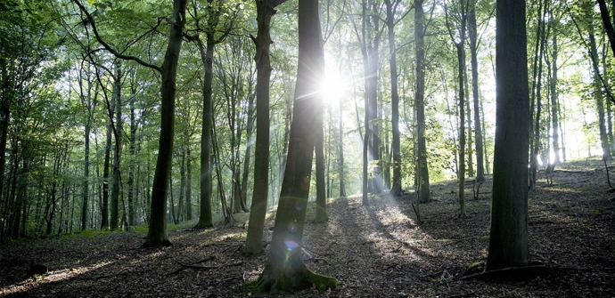
You will encounter not one, two but three forests on this route. Walk towards the Livierenbos - where wolves used to live - to end with a steep climb through the Pottelbergbos. Along the way, you also enter the Brakelbos. Plenty of variety, as you also pass the miners' path, a stretch of old railway line that is now a walking and cycling path. Along the way, you are also treated to phenomenal views over the surrounding fields.
automatic translation
 nodes to follow
0 km
1.1 km
1.2 km
1.9 km
2.8 km
4.2 km
4.9 km
5.6 km
5.9 km
6.9 km
7.4 km
7.7 km
9.3 km
10.1 km
10.5 km
10.8 km
12.1 km
12.1 km
Thursday, May 21, 2026 by Caro HaeltActual distance: 12.8 km, 6.2 km of which is unpaved. There are a few steep hills as well. Be sure to bring drinks (especially on hot days) because there are only places to eat and drink at the start (and end) points. There are welcome picnic tables at the start (Cabane Sylvie) and just before junction 26. Please note that between points 87 and 35, there are no clear signs indicating the route.
automatic translation
Wednesday, April 22, 2026 by M.P.It’s a truly beautiful route, with plenty of variety between descents and climbs. I’ve already done the route three times. I also often hike using the trail junctions. What’s unfortunate is that the connection between junction 5 and junction 6 has been cut off for quite some time. Will there be a solution?
automatic translation
Sunday, April 12, 2026 by Natalie VerstaenA really beautiful walk, very peaceful… with a fairly challenging stretch at the end, but otherwise a delightful walk
automatic translation
Tuesday, March 31, 2026 by B&B Het Stille GenoegenA real winner!
automatic translation
Thursday, February 19, 2026 by Christine DelcroixA very pleasant hike through beautiful woods. The paved roads are narrow and not very busy.
automatic translation
Tuesday, January 13, 2026 by Patrick MeersschaertVery beautiful walk, quite difficult, slippery in wet conditions, but really enjoyed it. Be careful at junction 26, didn't immediately find a sign to junction 43, had to guess the right direction. Still highly recommended for those who like lots of unpaved paths. A winner!
automatic translation
Wednesday, December 24, 2025 by Anne-sophie DierickxBlessed! A keeper!
automatic translation
Thursday, June 26, 2025 by Hilde Vanthuyne hildeBeautiful route on quiet roads, forest trails , cafe in Vloesberg , some altimeters but very doable .
automatic translation
Thursday, May 1, 2025 by M.D.Beautiful walk, wonderful views. There are picnic benches between nodes 35 and 26.
automatic translation
Wednesday, April 28, 2021 by R.D.Very beautiful but especially tough hiking trail, quite a few climbs but it is more than worth it! Many unpaved paths, beautiful vistas, beautiful forest paths, just watch out at the end there is a landslide, you can jump over it or go along the side, rather 12.5km than 11km.
automatic translation
Friday, October 10, 2025 by M.W.We are now in late 2025 and that landslide at the end in the forest of d'Hoppe is still there. Actually quite dangerous. Don't understand why that is not being addressed.
automatic translation
Saturday, March 27, 2021 by Jaak De vuystNice quiet hiking trail. Almost entirely traffic-free; A few sections are very muddy though. In times without corona there are also some very attractive terraces at the arrival
automatic translation
Sunday, March 7, 2021 by B.C.March 2021, hike focused on views. A little more variety and a little less paved is the difference tss 4 and 5 stars. Missed correct route to point 43, be careful !
automatic translation
Friday, November 6, 2020 by Jan TaildemanBeautiful autumn hike. Sturdy waterproof footwear is a must after a rainy spell. Beautiful views, much unpaved. Don't forget to bring your drinks as there is little or nothing along the way.
automatic translation
Sunday, June 28, 2020 by John DoeBeautiful. Forest, fields, fields. Paved and unpaved. Even our 5 year old child liked it. Will definitely come again.
automatic translation
Sunday, May 31, 2020 by Geert Vandekerkhove This is highly recommended for people who enjoy dirt roads in the woods and fields.
automatic translation
Saturday, May 30, 2020 by K.D.Beautiful, wooded hike!
automatic translation


 Upgrade to Premium Plus
