 Hiking
 Login
Login
 More
More
 EN
EN
 Premium
Commander Rasquin Route (shortening)
automatic translation
11.5 km • Bornem
3.1863 5 2.5/5
route offered by
Toerisme Provincie Antwerpen
 Addresse starting point (approximate)
Barelstraat 228, 2880 Bornem
 signage
The route is fully signposted with nodes.
 Description
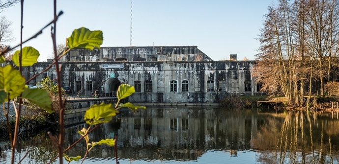
The Commander Rasquin Route starts at the Fort of Bornem and takes you past several relics from World War I and World War II. The fort is part of the outer belt of forts around Antwerp and was set up as an infantry support point during the interwar period. Later, in WWII, it primarily fulfilled a logistical role.
The walk is about 16 kilometers long and runs partly along field roads. Prefer a shorter route? No problem! The hike can be shortened by 5 kilometers.
Sights: Fort Bornem, Old station Oppuurs, Sint-Pietersburcht, Gildermonument, Grot van Branst, Sint-Bernardusabdij, various bunkers
automatic translation
 nodes to follow
0 km
0.7 km
2.3 km
3 km
4.3 km
4.3 km
4.3 km
5.6 km
6.1 km
6.5 km
8.4 km
11.4 km
Alternative versions
Saturday, May 3, 2025 by K.C.The junctions are not clearly retraceable. I had to do the walk in the opposite direction after walking the wrong way for a kilometer. Very nice unknown parts of Bornem seen!
automatic translation
Monday, January 11, 2021 by J.D.the route in itself is beautiful , sorry for the parts along the streets without feeder path , we walked it via nodes even though the description states that it is signposted with signs , which we did not see
automatic translation
Sunday, August 23, 2020 by Wilfried Van hoeckDear,I want the GPX file of this route.Where can I find this ? Mvg,Wilfried.
automatic translation
Saturday, May 23, 2020 by G.L.The first 3km and the last km of the route run along a narrow, busy street where there is no footpath. Dangerous, especially if you have children or dogs along. Regularly also difficult terrain such as large boulders or sand, so the route is not wheelchair accessible. That aside, a nice route through Bornem though.
automatic translation
Wednesday, April 8, 2020 by Bruno RottiersNice route
automatic translation


 Upgrade to Premium Plus
