 Hiking
 Login
Login
 More
More
 EN
EN
 Premium
Commander Rasquin Route (long version)
automatic translation
15.8 km • Bornem
3.2712 2 2.5/5
route offered by
Toerisme Provincie Antwerpen
 Addresse starting point (approximate)
Barelstraat, 2880 Bornem
 signage
The route is fully signposted with nodes.
 Description
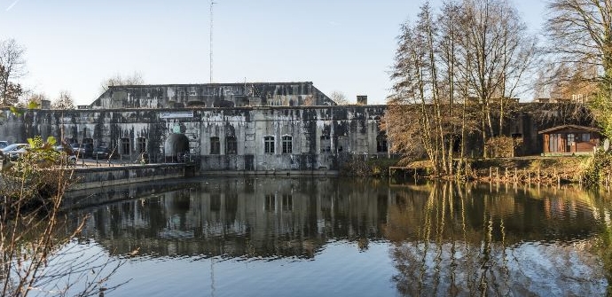
The Commander Rasquin Route starts at the Fort of Bornem and takes you past several relics from World War I and World War II. The fort is part of the outer belt of forts around Antwerp and was set up as an infantry support point during the interwar period. Later, in WWII, it mainly fulfilled a logistical task.
The walk is about 16 kilometers long and runs partly along field roads. Prefer a shorter route? No problem! The hike can be shortened by 5 kilometers.
Sights: Fort Bornem, Old station Oppuurs, Sint-Pietersburcht, Gildermonument, Grot van Branst, Sint-Bernardusabdij, various bunkers.
automatic translation
 nodes to follow
0 km
0.7 km
2.2 km
2.5 km
2.7 km
4 km
4.9 km
5.6 km
6 km
6.1 km
6.7 km
7.4 km
8.7 km
9.9 km
10.5 km
10.9 km
12.8 km
15.8 km
Alternative versions
Sunday, April 18, 2021 by Ilse CornelissensAgree with other review. Better start at sports hall, you can park there. At starting point 41 not. Many paved, busy roads at times. Not such a topper this walk
automatic translation
Wednesday, September 9, 2020 by K.D.The route is well marked, the nodes are mostly easy to find. Towards the end, from node 29 on, it is more difficult to follow the correct route. Fortunately, the map helps you well. The highlight is also the starting point. Otherwise, the route was not very exciting, many busy paved roads. Tip: start at sports center Bornem.
automatic translation


 Upgrade to Premium Plus
