 Biking
 Login
Login
 More
More
 EN
EN
 Premium
Who calls the ferryman bike route
automatic translation
44.4 km • Wichelen
 official route
5.80122 5 4.7/5
 Addresse starting point (approximate)
Hoogstraat, 9260 Schellebelle
 signage
The route is fully signposted with nodes.
 Description
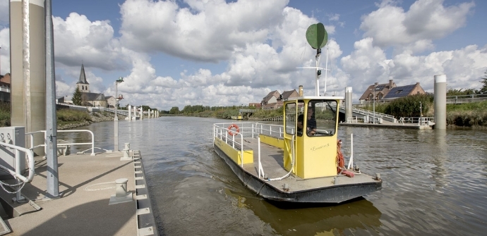
This bike route starts from the Schellebelle ferry, the gateway to the Kalken Meersen. Be sure to stop at the butterfly garden and the duck decoy at the Donkmeer. Berlare's beautifully landscaped castle park is also on the route.
The Wie belt de veerman bicycle route is offered to you by Routen, an initiative of Tourism East Flanders.
automatic translation
 nodes to follow
0 km
0.1 km
0.1 km
4.6 km
6.7 km
8 km
11.5 km
15.4 km
17.1 km
18.3 km
21.1 km
21.4 km
22.9 km
24.9 km
25.9 km
26.7 km
28.8 km
30.3 km
32.3 km
33.9 km
35.2 km
36.1 km
38.3 km
39.5 km
42.6 km
44.3 km
Monday, August 18, 2025 by P.D.I rode them this afternoon very nice but a problem from node 11 to node 15 is a problem because you node 15 is hard to find
automatic translation
Sunday, August 17, 2025 by Roger Van de MeersscheSuper fun route through different landscapes. 100% enjoyment.
automatic translation
Sunday, June 19, 2022 by V.C.Beautiful, quiet bike ride. Ideal tour for city bikes. Variation in the landscape. Along the Scheldt, in meadows....
automatic translation
Sunday, August 23, 2020 by M.C.Very nice bike route. Many rural roads and some off road (which is also very nice with a city bike). We did not take the ferry in Schellebelle to cross the Scheldt but continued on to Wetteren to cross the Scheldt via the cyclists' bridge and then return along the other side of the Scheldt.
automatic translation
Tuesday, July 21, 2020 by P.D.One star less for the 3km of gravel roads with the course bike, one star more for the fun ferry crossing. Goes through the greenest spots in the area and bike paths along the dikes. Few in traffic. Highly recommended.
automatic translation


 Upgrade to Premium Plus
