 Hiking
 Login
Login
 More
More
 EN
EN
 Premium
Rijtmeersen hiking trail
automatic translation
8.9 km • Oudenaarde
 official route
7.5323 6 2.5/5
 Addresse starting point (approximate)
Mandenmakersstraat 7, 9700 Oudenaarde
 signage
The route is fully signposted with nodes.
 Description
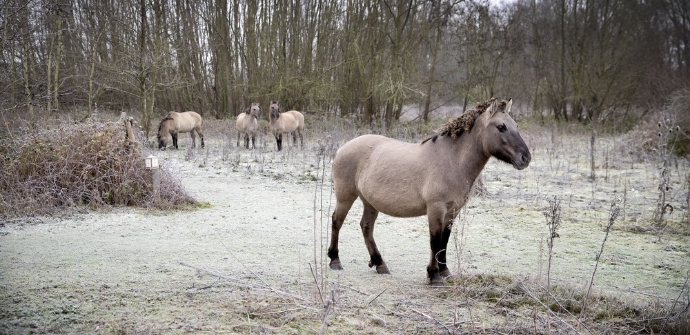
In the Scheldt Valley between Nederename and Nederzwalm lies a string of small and large nature reserves where walking is pleasantly flat. Start in Welden and after about 2.5 kilometers of Scheldejaagpad, dive into the Rijtmeersen, a rugged chunk of nature where all year round konik horses and galloway cattle roam the grazing block.Attention: dogs are not allowed in the grazing zones.
TheRijtmeersen hiking trailis offered to you byRouten, an initiative of Tourism East Flanders.
automatic translation
 nodes to follow
0 km
1.2 km
2 km
2.5 km
4.8 km
5.2 km
6.4 km
7.3 km
8.4 km
8.5 km
9 km
Thursday, November 3, 2022 by Gregor LegeinThis walk started nicely along fields, farms and quiet along the shell bank until we came to the Rijtmeersen!?!!? No dogs allowed! There you are🥲 Then we walked on to the viaduct (no nodes along there, sorry) and before the viaduct take a left at the first street again left there until WKP23 and you can continue to 16.
automatic translation
Sunday, August 29, 2021 by D.D.Nice hike, but only the part through the Rijtmeersen is really interesting. However, that part is particularly short.
automatic translation
Sunday, January 10, 2021 by I.C.Beautiful nature walk
automatic translation
Saturday, December 5, 2020 by L.m.v.c. VandrommeVery nice hike. Lots of mud but lots of nature
automatic translation
Friday, December 4, 2020 by R.H.Disillusionment!
automatic translation
Wednesday, November 25, 2020 by johan van lanckerDisillusioned !!! Here are many other possibilities, which are not used. Change title to along the rijtmeersen instead of through the rijtmeersen, maybe 300 meters effectively walked in it sorry!!!
automatic translation


 Upgrade to Premium Plus
