 Hiking
 Login
Login
 More
More
 EN
EN
 Premium
Scheldt side hiking trail loop 1
automatic translation
7.7 km • Wortegem-Petegem
 official route
5.4745 7 3.8/5
 Addresse starting point (approximate)
Kortrijkstraat 70, 9790 Elsegem
 signage
The route is fully signposted with thematic signs (no nodes).
 Description
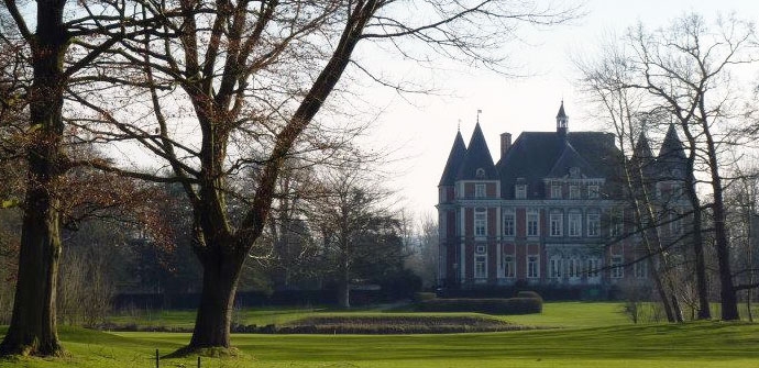
Walk through the Scheldemeersen and along the old Scheldemeander. A must for nature and history lovers!
The Scheldt side walking route loop 1 is offered to you by Routen, an initiative of Tourism East Flanders.
automatic translation
Saturday, July 26, 2025 by Kimberley Versmessenot really recommended if you don't like flat trails. you also walk in between the golf course where the golf carts literally drive you off the course. they also watch you to make it clear you are not supposed to walk there....
automatic translation
Friday, July 23, 2021 by K.B.The signs are not always clear. On the information board at the entrance of Domein de Ghellinck 2 walks are mentioned, one starting at the church in Elsegem and another one starting at Domein de Ghellinck. Signs are different, red or green, depending on the loop.
automatic translation
Sunday, April 4, 2021 by C.S.Beautiful walk along the Scheldt, the old arm of the Scheldt and the beautiful golf courses. Domain de Ghellinck at the beginning and end is also worth walking through.
automatic translation
Thursday, March 11, 2021 by Y.B.Beautiful walk but the signs are not always clearly placed
automatic translation
Sunday, February 21, 2021 by I.A.Beautiful hike! The start is at the parking lot of the Domein de Ghellinck and not at the church of Elsegem.
automatic translation
Monday, July 27, 2020 by Patrick DejongheA very nice and quiet walk with a pit stop at the castle of Elsegem. enjoyed it. Highly recommended.
automatic translation
Monday, July 27, 2020 by Patrick DejongheThis walk does start at the church of Elsegem but not Kortrijkstraat 70 Elsegem as stated.
automatic translation


 Upgrade to Premium Plus
