 Hiking
 Login
Login
 More
More
 EN
EN
 Premium
Gourmand hiking trail
automatic translation
15.4 km • Zwalm
 official route
6.88411 11 3.7/5
 Addresse starting point (approximate)
Gaverbosdreef 1, 9630 Zwalm
 signage
The route is fully signposted with nodes.
 Description
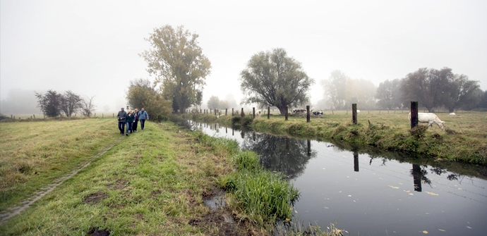
A delightful walk along the Zwalm Brook, with many tasty stops to regain your strength. You pass one water mill after another during your hike, such as the Zwalmmolen and the Terbiestmolen. The walk crosses 2x through the green Gaverbos forest.
TheGourmand walking routeis offered to you byRouten, an initiative of Tourism East Flanders.
automatic translation
 nodes to follow
0 km
1.3 km
1.5 km
2 km
3.2 km
3.5 km
4.1 km
4.5 km
4.8 km
5.3 km
5.9 km
6.7 km
7.5 km
8.9 km
9 km
9.7 km
10 km
11.7 km
13.6 km
14.2 km
14.7 km
15.3 km
Thursday, March 12, 2026 by A.D.Nice walk at the beginning, but be careful in sector 83! When you go through the gate to the meadow, there is an arrow pointing straight ahead, but you have to turn right to continue over the fence via a ladder. Also in sector 69, at the crossing on Hundelgemsebaan, there are no signs, so just cross and then turn right onto Kerkstraat!
automatic translation
Sunday, May 25, 2025 by Peter Van den Sompelvery nice walk top this
automatic translation
Friday, March 19, 2021 by Gerrit Gerrit van hauteNice walk but walk them in the other direction then you have at the end about 4 kilometers of beautiful nature along the Zwalm Brook. Indeed unfortunate almost all roads are paved but nevertheless....
automatic translation
Tuesday, January 26, 2021 by Willy De Regge-HeyseNice varied hike, with beautiful views. Highly recommended, even after the rains of the past period.
automatic translation
Sunday, January 24, 2021 by Danielle GhyselsVery nice hiking trail...definitely recommended!
automatic translation
Monday, August 10, 2020 by Dominique DerveauxBeautiful hike, large sections in the forest allowing plenty of shade on hot summer days. Also feasible for the less experienced hiker.
automatic translation
Sunday, August 2, 2020 by Domi CallensVery quiet cool hike. Beautiful quiet green spots. Really worth it!!!
automatic translation
Tuesday, July 28, 2020 by D.D.Almost the entire route is on paved trails. The first part along the Zwalm on a pedestrian/bicycle path. Beautiful, atmospheric corners along the Zwalm. Indeed many eating places, but on a Tuesday in late July, only 1 open (at nr 10). From nr 10 the route runs almost entirely on streets. Quiet though, and except for the part between 3 and 2 with not too many buildings. All in all an OK trail, but certainly not among the more interesting ones.
automatic translation
Sunday, June 28, 2020 by M.K.Don't be discouraged by the first part of the hike, which runs along the track, because afterwards you dive into nature along the course of the Zwalm river. Until nr 10 you'll pass several places to eat or drink. Once there you walk between fields with beautiful views. With occasional slight inclines. The starting and finishing point is also situated at a restaurant.
automatic translation
Monday, June 1, 2020 by Dirk GHIJSELINCKBeautiful route, walking in full nature in the Zwalm region.
Highly recommended for someone who wants to combine peace and greenery.
automatic translation
Saturday, May 23, 2020 by françois-rosa baele coenewe enjoyed this route.Very nice walk lots of greenery at the end a little surprise uphill
automatic translation


 Upgrade to Premium Plus
