 Hiking
 Login
Login
 More
More
 EN
EN
 Premium
Panoramic hiking trail
automatic translation
17.5 km • Kluisbergen
 official route
11.08652 21 4.7/5
 Addresse starting point (approximate)
Kwaremontplein, 9690 Kwaremont
 signage
The route is fully signposted with nodes.
 Description
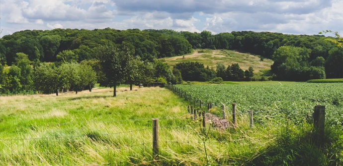
Stroll through the charming villages of Zulzeke and Kwaremont. Kwaremont is known as an artists' village and from the Tour of Flanders. Enjoy magnificent panoramas from the Hotond (150 m), the highest hilltop in East Flanders. The old windmill at the top was converted into a viewpoint.
The Panoramic hiking trail is offered to you by Routen, an initiative of Tourism East Flanders.
automatic translation
 nodes to follow
0 km
0.3 km
1.3 km
1.9 km
3.2 km
3.9 km
4.2 km
5.2 km
6.5 km
7.4 km
7.8 km
9 km
9.6 km
10.4 km
10.8 km
11.9 km
12.5 km
13.9 km
15.1 km
15.5 km
15.6 km
16.7 km
17.5 km
Saturday, May 2, 2026 by L.C.Highly recommended! A very beautiful, varied, and enjoyable route!
automatic translation
Wednesday, April 29, 2026 by Karen Van HulWhat a beautiful route!
automatic translation
Sunday, December 14, 2025 by Anne-sophie DierickxFor the third time, and remains for me the most beautiful of the Flemish Ardennes. Café in Zulzeke not always accessible and only cash, walk a quarter of an hour (which by the way is very beautiful part) you can enjoy at the Hotond.
automatic translation
Sunday, November 9, 2025 by Tom MadouBeautiful route with many "ups and downs". Beautiful views. 5 benches scattered along the route.
automatic translation
Sunday, September 14, 2025 by Jeroen BorremansVery nice route!
automatic translation
Thursday, August 14, 2025 by Kimberley Versmessenot buggyproof though nice that you get to walk among the cows.
automatic translation
Friday, June 6, 2025 by Jan EngelsVery nice route! Highly recommended... and indeed do not forget café Hotond (500m detour)
automatic translation
Saturday, May 17, 2025 by T.N.wow , deserves a Michelin star 🌟🌟🌟🌟
automatic translation
Tuesday, October 15, 2024 by A.V.Very nice walk! Rather 16km though! Very tough, but such a beautiful views 😍
automatic translation
Monday, January 30, 2023 by C.C.Highly recommended! Beautiful route
automatic translation
Sunday, November 13, 2022 by Geert DepickereVery nice hike. A calf bite though, but more than made up for by the beautiful views. In places where it used to be muddy, there are now wooden walkways or wood mulches. A small detour to the Hotond cafe is also recommended :-)
automatic translation
Thursday, April 22, 2021 by M.D.nice hike, but tough! definitely recommended for people who are in good shape.
automatic translation
Saturday, April 10, 2021 by Linda FastenaekelsVery beautiful and varied hike. Spicy though, good condition required. However, the route in the GPX file is in reverse order.
automatic translation
Sunday, January 10, 2021 by Caroline De CockBeautiful hike, indeed very varied from forest over meadows to hiking trails. Beautiful trail from start to finish with indeed many views. Some fitness is handy here. Recommended
automatic translation
Saturday, December 26, 2020 by werner knopBeautiful walk in the heart of the Tour of Flanders. Especially at the beginning pay attention to the signposts because if you miss the first one you are 1 km further before you realize it. Very nice walk
automatic translation
Monday, December 14, 2020 by Jan OosterlynckSuperb hike, with beautiful views. One thing not to forget, sturdy and waterproof hiking boots (!!!) as the trail is extremely muddy and slushy at the moment.....
automatic translation
Saturday, December 5, 2020 by L.V.Very nice, quiet route. Varied landscape, from the forest to the open plains. Highly recommended.
automatic translation
Tuesday, November 3, 2020 by Tom Van wichelenSuper route. Do it! ;-)
automatic translation
Monday, November 2, 2020 by P.V.super nice route
automatic translation
Sunday, September 13, 2020 by H.F.Beautiful, varied hike along quiet trails and roads. Beautiful panoramas throughout the hike. Well marked.
automatic translation
Thursday, July 9, 2020 by Eddy Devolderwell marked, beautiful panoramas, varied through fields, meadows, forests, small paved roads, ...
automatic translation


 Upgrade to Premium Plus
