
 Hiking
 Login
Login
 More
More
 EN
EN
 Premium
Potaardewandeling
7.4 km • Grimbergen
 official route
2.9945 1 4/5
route offered by

 Addresse starting point (approximate)
kruispunt Potaarde met Oude Mechelsestraat, 1853 Strombeek-Bever
 signage
The route is signposted with thematic signs (no nodes). You can use a GPS device or our app to follow the route through the virtual nodes.
 Description
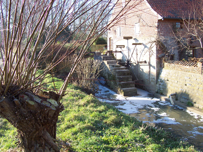
Walk along the border between Grimbergen and the Brussels Region. You’re literally walking right next to the R0, with the monotonous roar of cars in the background, while looking out over the fields. For a bit, you follow the Maalbeek to ’s Gravenmolen, the oldest watermill in the municipality. Hof ter Weerdestraat is an important historic street where a moated castle and two large tenant farms once stood. The castle is gone, but the two farms are still there: Hof ter Weerde and the Spiegelhof. Both are centuries old and designated as historic monuments.
Before you set out: This is a walk on a digital walking network. The junctions are not marked on the ground. Follow the hexagonal red-and-white signs bearing the name of the walk.
automatic translation
 nodes to follow
0 km
0.3 km
0.9 km
2.9 km
3.1 km
3.8 km
4.7 km
5.3 km
6.1 km
6.6 km
7.4 km
Friday, October 22, 2021 by J.D.quite a nice walk , already done 2x including 1x in reverse direction
automatic translation
Tuesday, October 3, 2023 by Kurt Leenknechtdear we are big fans of hiking but don't know how to use those visual nodes do you have any advice for us? thanks a lot in advance
automatic translation



 Upgrade to Premium Plus


