 Hiking
 Login
Login More
More EN
EN Premium
Sloping Grimbergen hike
automatic translation
4.9 km • Grimbergen
 official route
route offered by
 Addresse starting point (approximate)
's Gravenmolen, 's Gravenmolenstraat 70, 1850 Grimbergen
 signage
The route is not signposted. Use a GPS device or our app to follow the route through the virtual nodes.
 Description
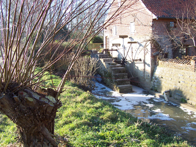
You start at the 's Gravenmolen, a water mill on the Maalbeek, which is also the oldest mill in Grimbergen. Start your tour here at Spiegelhof and Potaardehof, two farms in the Maelbeek valley. Along the way you pass the park garden with beautiful flower meadow of the psychiatric clinic Sint-Alexius.
NOTE: This is a hike on a virtual hiking network. The nodes are not signposted on the property.
This walk is offered by the Regional Landscape Brabantse Kouters in cooperation with the municipality.
automatic translation
 nodes to follow
0 km
0 km
0.2 km
0.2 km
0.2 km
0.9 km
1.8 km
2.2 km
2.8 km
4.8 km
4.9 km


 Upgrade to Premium Plus
