 Hiking
 Login
Login
 More
More
 EN
EN
 Premium
Kesterheide-Lombergveldwandeling
9.4 km • Pajottegem
 official route
5.46514 11 4.5/5
route offered by
 Addresse starting point (approximate)
(bus stop) Edingsesteeweg 209, 1755 Pajottegem
 signage
The route is fully signposted with nodes.
 Description
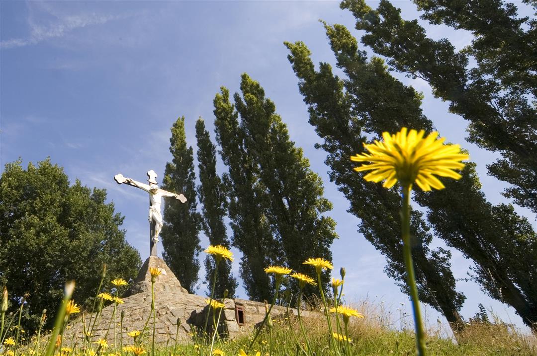
A walk to the roof of the Pajottenland: at 112 meters, the Kesterheide is the highest point in the region. You can even see the Atomium from here! There’s plenty to discover on the hillsides, such as the Iron Man, a geographical landmark since 1867. The Pervivo memorial honors all the children who have died from metabolic disorders. And that mysterious fenced-off compound with modern, white domes? A “top-secret” NATO communications post. The Paddenbroek Rural Center at the foot of the Kesterheide was given a glass enclosure, a true architectural masterpiece.
automatic translation
 nodes to follow
0 km
0.2 km
0.3 km
1.2 km
1.3 km
1.5 km
2.1 km
2.6 km
2.7 km
3.3 km
3.9 km
4.4 km
5.2 km
5.7 km
6.3 km
6.5 km
7.3 km
8.2 km
9 km
9.1 km
9.1 km
9.2 km
9.4 km
Monday, September 1, 2025 by Liesbeth StraetmansWhat a beautiful hike. A lot of trails we didn't know yet on Kesterheide. We were pleasantly surprised.
automatic translation
Wednesday, June 5, 2024 by R.V.Very nice walk through the fields and forest around Kesterheide.
automatic translation
Friday, May 28, 2021 by L.J.Very surprising "farm-buiten" 20 km from the capital. Beautiful rolling countryside and beautiful views. Easy trail, but good walking shoes are really necessary! One drawback: no car parking at the start of the trail.
automatic translation
Thursday, March 18, 2021 by L.V.We left at junction 215 (limited parking) and then did junctions 220-218-217-216 and continued from there. In this way we were able to avoid arriving twice at node 215 and this is also how the route is described in a brochure we had. The problem between node 258 and 256 has since been solved (thanks)
automatic translation
Monday, January 4, 2021 by N.N.Departure street right across the staging area (buses). Extremely beautiful walk. Only country roads, forests, ... no paving. During rainy periods it can be very muddy, especially on the Kesterheide. But with solid hiking boots it certainly succeeds and it remains enormously beautiful. Definitely recommended. Attention at signposting 256 there is indeed a mistake
automatic translation
Monday, December 14, 2020 by Eddy TimmermansVery nice hike along quiet roads. In rainy weather some trails are very muddy but we take that for granted. Good signage.
automatic translation
Saturday, November 21, 2020 by Pieter-Jan Van DammeWonderful walk with beautiful stretches of forest, wonderful views and romantic paths. You even walk through a farm at one point. The white spheres of the NATO communications center are a curious sight during the second half of the hike. Definitely recommended!
automatic translation
Sunday, June 28, 2020 by Geert Delangre Very nice hike lots of small field roads fun to do . Definitely recommended if you like being in nature .
automatic translation
Sunday, June 7, 2020 by P.D.Beautiful walk
Attention from node 258 towards node 256 there is a problem. At the end of the Berghomstraat there is an arrow 256 to the left. This is not correct, you have to go to the right and then a bit further to the left, for which there is no arrow, to the Hoogheideweg (small road).
automatic translation
Saturday, May 16, 2020 by J.V.Beautiful hike. One of the nicer ones in the Pajottenland.
automatic translation
Sunday, April 14, 2019 by Saskia De TroyerA real bijouken to do, huge views, nice trails, beautiful piece of nature, highly recommended
automatic translation


 Upgrade to Premium Plus
