 Hiking
 Login
Login More
More EN
EN Premium
Houwaart Mountain Walk
automatic translation
9.2 km • Tielt-Winge
 official route
1.7100 10 4.2/5
route offered by
 Addresse starting point (approximate)
Sint-Denijskerk, Haldertstraat 1B, 3390 Houwaart (Tielt-Winge)
 signage
The route is fully signposted with nodes.
 Description
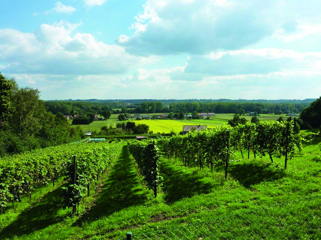
Enjoy a beautiful walk along the southern flank of Houwaart Mountain. If the sun is cooperating, you'll imagine yourself in a southern French vineyard. Start at the Sint-Denijskerk in the center of Houwaart and soon you get an open view of the rows of vines. An unpaved field path takes you to the lovely St. Joseph's Chapel, with a resting bench, and a little further on you arrive at the first vineyard. You climb a bit higher still to the Vineyard Street. Take your time here to enjoy the view over the valley of the Motte with a view of Houwaart.
This hike is offered by Tourism Flemish Brabant.
automatic translation
 nodes to follow
0 km
0.1 km
0.5 km
1 km
1.6 km
2.2 km
3.9 km
4.2 km
5.1 km
5.5 km
6 km
6.9 km
8.7 km
9.1 km
9.2 km
Saturday, October 21, 2023 by P.P.beautiful route. I extend them as far as Nieuwrode with part of the St-Job walk and see more of the tree farm that way, too.
automatic translation
Saturday, December 24, 2022 by G.J.Beautiful varied hike! Some noise from the express road though, especially at the beginning, quiet and peaceful afterwards, few people encountered.
automatic translation
Tuesday, August 23, 2022 by Rosine Van HemelryckThe most interesting parts of this route are the vineyards and nurseries.Unless you really just want to eat miles, you're better off going from 246 straight to the vineyards from 226 - the stretch before that is nothing. For those who like botany, the tree nurseries (really all kinds of little trees) between 153 and 151 are more than worthwhile.
automatic translation
Sunday, October 25, 2020 by Guy Van dammeIt is a varied hike, with occasional climbs and beautiful views. The vines adorned in autumn colors gave it all a fairy-tale touch. The rain had turned many roads into mud puddles. Nevertheless, we thoroughly enjoyed this short hike. We give this hike a well-deserved 8.5/10.
automatic translation
Thursday, October 22, 2020 by Victor SwittenWalk done on 06.09.2020. Wonderful hike, tough climbs, beautiful views.
automatic translation
Sunday, August 9, 2020 by V.L.Wonderful hike via dirt roads - beautiful vistas - from now on we'll drink more native wine - done on Sunday, Aug. 9, 20, which did involve some mountain bikers
automatic translation
Monday, June 8, 2020 by Annick Van DesselWonderful and varied walk in our own region along vineyards, hollow roads, open fields, meadows, ... hardly bothered by traffic ... just enjoy nature ... highly recommended !
automatic translation
Monday, March 9, 2020 by V.E.Quite a bit of noise from the state highway.
automatic translation
Tuesday, May 21, 2019 by anja Van Eyken Anjabeautiful route...distant views and beautiful vineyards done May 21, 2019
automatic translation
Tuesday, February 26, 2019 by V.V.very nice hike lots of variety beautiful views and above all unwind.We did this on the warmest Feb. 26, 2019
automatic translation


 Upgrade to Premium Plus
