 Biking
 Login
Login
 More
More
 EN
EN
 Premium
Cycling between Duinengordel and Terhills
automatic translation
49.6 km • 3660 Oudsbergen
 official route
12.90147 6 4.7/5
 Addresse starting point (approximate)
Sentower Park, Leemkuilstraat 21
 signage
The route is fully signposted with nodes.
 Description
With this bicycle route you will explore the northern part of the Hoge Kempen National Park. You start in Oudsbergen, in the Duinengordel area, a wooded area known for its land dunes. Via Opglabbeek and As you meander through a varied landscape of groves, stream valleys and meadows.
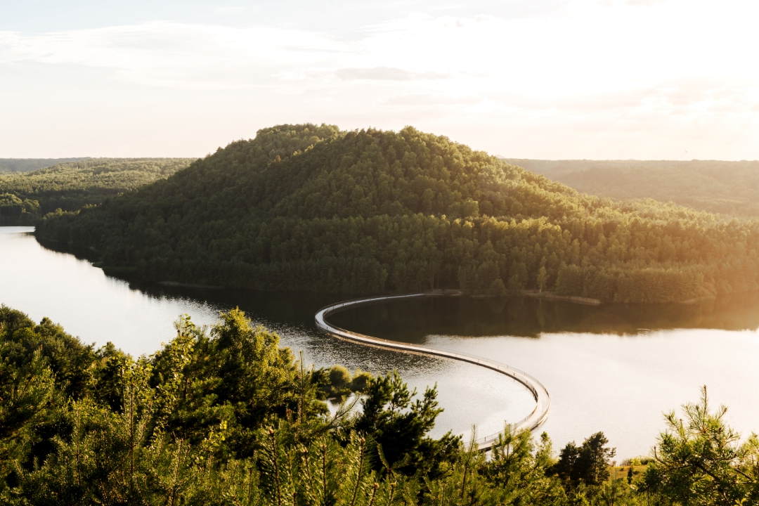
At As Station, artful graffiti trains adorn the old station site along the Coal Railroad. In a straight line you cycle towards Terhills, where "Cycling between Terrils" offers a clever piece of cycling infrastructure. The floating bicycle bridge takes you from the twin terrils to the panoramic terril right across the gravel lake, a unique construction of its kind. The mine site itself calls for a short stop and an ascent of one of the shaft towers.
Along the Zuid-Willemsvaart canal you cycle to hidden gem Bergerven, where wild grazers greet you along vast expanses of water. You follow the stream of the Bosbeek through a wooded area back to the starting point near the Oudsberg, where you conclude this varied route.
automatic translation
 nodes to follow
0 km
0.4 km
2.5 km
6.5 km
10.2 km
12.3 km
12.8 km
12.9 km
13 km
18.4 km
21.7 km
23.9 km
29.9 km
30 km
30.9 km
31.5 km
32.3 km
36.3 km
41.5 km
43.4 km
43.8 km
46.3 km
49.5 km
Monday, April 27, 2026 by Cindy VandeurzenA really beautiful route taking in the gems of Opglabbeek, As, Lanklaar, Maasmechelen, Neeroeteren, Opoeteren, and Gruitrode.
It’s a little over 50 km.
We’ll definitely do this one again!
automatic translation
Sunday, March 29, 2026 by E.P.A beautiful bike route through varied terrain. It includes a few steep climbs that can be challenging for standard bikes.
automatic translation
Wednesday, July 23, 2025 by J.B.Nice ride, but we came to 60.45Km ;)
automatic translation
Sunday, May 18, 2025 by Dominique DelaunoyVery nice route, on beautiful paths, possibility of having a good home-made ice cream, I recommend.
automatic translation
Wednesday, January 1, 2025 by F.V.very beautiful, varied, ... we return satisfied :-)
automatic translation
Friday, September 20, 2024 by J.H.Nice through traffic-free roads, especially Terhills where it was very busy though. The Litzberg is a thing though, especially on busy days there will be accidents as it is too steep and from the other side too fast.
automatic translation


 Upgrade to Premium Plus
