Loading...

Kempen Route Limburg

automatic translation

121 km • Maasmechelen

Icon official route official route

4.1114 0 0/5

121 km 0.0 km 0.0 km

route offered by

Badge of official route

more info

Icon starting point Addresse starting point (approximate)

Visit Maasmechelen, Zetellaan 35

Icon type signage of route signage

The route is fully signposted with thematic signs (no nodes).

5m 5m 5m 5m
© Visit Limburg

Icon description route Description

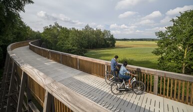
The Kempen Route connects Terhills, gateway to Hoge Kempen National Park, with the city of Antwerp. Along the former Limburg Coal Railway you string together mining sites, from C-mine to be-MINE, each one an impressive industrial heritage with a contemporary interpretation and surrounded by vast natural areas. The unique cycling experiences "Cycling through the Heaths" in the Hoge Kempen National Park and "Cycling through the Trees" in Bosland are right on the route and are both literally and figuratively a highlight of the route.

automatic translation

Icon nodes to follow nodes to follow

Image node 56
0 km
Image node 55
2.3 km
Image node 502
4.5 km
Image node 60
9 km
Image node 60
9.4 km
Image node 61
13 km
Image node 550
16.5 km
Image node 551
20.7 km
Image node 551
20.8 km
Image node 565
23.5 km
Image node 565
23.7 km
Image node 41
24.1 km
Image node 41
24.1 km
Image node 40
26.2 km
Image node 39
28.7 km
Image node 512
29.3 km
Image node 322
33.4 km
Image node 508
34.7 km
Image node 509
40.2 km
Image node 73
41.1 km
Image node 73
41.1 km
Image node 548
43.6 km
Image node 74
44.6 km
Image node 79
46.1 km
Image node 305
52.4 km
Image node 300
53.5 km
Image node 316
56.6 km
Image node 311
59.3 km
Image node 311
59.3 km
Image node 307
60.3 km
Image node 518
65.1 km
Image node 310
67.5 km
Image node 341
74.4 km
Image node 340
76.7 km
Image node 337
78.7 km
Image node 342
79.2 km
Image node 554
84.9 km
Image node 554
84.9 km
Image node 555
88 km
Image node 277
88.5 km
Image node 275
93.7 km
Image node 275
93.8 km
Image node 272
99.1 km
Image node 272
99.3 km
Image node TP
99.5 km
Image node 272
99.9 km
Image node 272
100 km
Image node 255
103.3 km
Image node 264
107.2 km
Image node 552
110.3 km
Image node 552
110.5 km
Image node 266
111.2 km
Image node 268
113.6 km
Image node 267
116.9 km
Image node 267
117.2 km
Image node 260
118.5 km
Image node 260
118.5 km
Image node 260
118.6 km
Image node 75
121.3 km
This route does not have any reviews yet. Be the first!
Rate route!

Which POI do you want to show on the map?

Experimental cycling network
Unsigned icon

The route you have chosen runs (partly) along an experimental virtual cycling node network (the blue-coloured nodes and sections on the map).

You must be logged in to plan routes here.

Experimental cycling network
Unsigned icon

The route you have chosen runs (partly) along an experimental virtual cycling node network (the blue-coloured nodes and sections on the map).

These routes are not controlled in the field. Before you start cycling here, take a minute to read what an experimental cycling node network is and what rules you should follow when cycling here.